


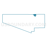
Voting District 262, Pima County, Arizona
About
Outline

Summary
| Unique Area Identifier | 525482 |
| Name | Voting District 262 |
| County | Pima County |
| State | Arizona |
| Area (square miles) | 53.84 |
| Land Area (square miles) | 53.84 |
| Water Area (square miles) | 0.00 |
| % of Land Area | 100.00 |
| % of Water Area | 0.00 |
| Latitude of the Internal Point | 32.46344490 |
| Longtitude of the Internal Point | -111.12559190 |
Maps

Graphs
Select a template below for downloading or customizing gragh for Voting District 262, Pima County, Arizona


Neighbors
Neighoring Voting District (by Name) Neighboring Voting District on the Map
- Voting District 223, Pima County, AZ
- Voting District 261, Pima County, AZ
- Voting District 282, Pima County, AZ
- Voting District 364, Pima County, AZ
- Voting District 379, Pima County, AZ
- Voting District 396, Pima County, AZ
- Voting District 397, Pima County, AZ
- Voting District 415, Pima County, AZ
- Voting District 6, Pima County, AZ
- Red Rock Voting District, Pinal County, AZ
Top 10 Neighboring County Subdivision (by Population) Neighboring County Subdivision on the Map
- Tucson CCD, Pima County, AZ (853,603)
- Florence CCD, Pinal County, AZ (34,685)
- Marana CCD, Pima County, AZ (34,429)
Top 10 Neighboring Place (by Population) Neighboring Place on the Map
Top 10 Neighboring Elementary School District (by Population) Neighboring Elementary School District on the Map
Top 10 Neighboring Secondary School District (by Population) Neighboring Secondary School District on the Map
Top 10 Neighboring Unified School District (by Population) Neighboring Unified School District on the Map
Top 10 Neighboring State Legislative District Lower Chamber (by Population) Neighboring State Legislative District Lower Chamber on the Map
- State House District 23, AZ (370,479)
- State House District 25, AZ (208,220)
- State House District 26, AZ (195,881)
Top 10 Neighboring State Legislative District Upper Chamber (by Population) Neighboring State Legislative District Upper Chamber on the Map
- State Senate District 23, AZ (370,479)
- State Senate District 25, AZ (208,220)
- State Senate District 26, AZ (195,881)
Top 10 Neighboring 111th Congressional District (by Population) Neighboring 111th Congressional District on the Map
Top 10 Neighboring Census Tract (by Population) Neighboring Census Tract on the Map
- Census Tract 44.27, Pima County, AZ (8,138)
- Census Tract 46.38, Pima County, AZ (7,416)
- Census Tract 8.02, Pinal County, AZ (4,154)
- Census Tract 44.31, Pima County, AZ (3,903)
- Census Tract 46.39, Pima County, AZ (3,389)